《农业气象学》课程教学资源(文献资料)Clouds 1/2
CloudsContentsWhatcauses cloudsIvpes of cloudsLow cloudsMedium cloudsHigh cloudsWhatinfluencesthe colour of clouds?Whydocloudsstopgrowingupwards?Why are there no clouds on some days?Measuring cloudsThe formation of precipitationShort-answer questionsWhatcausescloudsA cloud is defined as'a visible aggregate ofminute droplets of water or particles of ice ora mixture ofboth floating in the free air'. Each droplet has a diameter of about a hundredth of a millimetre and eachcubic metre of air will contain 100 milion droplets. Because the droplets are so smal,they can remain inliquidformintemperaturesof-3oC.Ifso,theyarecalledsupercooleddropletsClouds at higher and extremely cold levels in the atmosphere are composed of ice crystals - these canbe abouta tenth of a millimetre long.Clouds form when the invisible water vapour in the air condenses into visible water droplets or icecrystals.For this to happen, the parcel of air must be saturated,i.e. unable to hold all the wateritcontains in vapour fom, so it starts to condense into a liquid orsolid form.Thereare two ways bywhichsaturation is reached.(a) By increasing the water content in the air,e.g. through evaporation, to a point where the air can holdno more.(b)Bycoolingtheairsothatitreachesitsdewpoint-thisisthetemperatureatwhichcondensationoccurs, and is unable to'hold'any more water.Figure 1 shows how there is a maximum amount of watervapour the air,at a given temperature, can hold. In general, the warmer the air, the more water vapourit can hold. Therefore,reducing its temperature decreases its ability to hold water vapour so thatcondensation occurs
Clouds Contents What causes clouds Types of clouds Low clouds Medium clouds High clouds What influences the colour of clouds? Why do clouds stop growing upwards? Why are there no clouds on some days? Measuring clouds The formation of precipitation Short-answer questions What causes clouds A cloud is defined as 'a visible aggregate of minute droplets of water or particles of ice or a mixture of both floating in the free air'. Each droplet has a diameter of about a hundredth of a millimetre and each cubic metre of air will contain 100 million droplets. Because the droplets are so small, they can remain in liquid form in temperatures of -30 °C. If so, they are called supercooled droplets. Clouds at higher and extremely cold levels in the atmosphere are composed of ice crystals — these can be about a tenth of a millimetre long. Clouds form when the invisible water vapour in the air condenses into visible water droplets or ice crystals. For this to happen, the parcel of air must be saturated, i.e. unable to hold all the water it contains in vapour form, so it starts to condense into a liquid or solid form. There are two ways by which saturation is reached. (a) By increasing the water content in the air, e.g. through evaporation, to a point where the air can hold no more. (b) By cooling the air so that it reaches its dew point — this is the temperature at which condensation occurs, and is unable to 'hold' any more water. Figure 1 shows how there is a maximum amount of water vapour the air, at a given temperature, can hold. In general, the warmer the air, the more water vapour it can hold. Therefore, reducing its temperature decreases its ability to hold water vapour so that condensation occurs
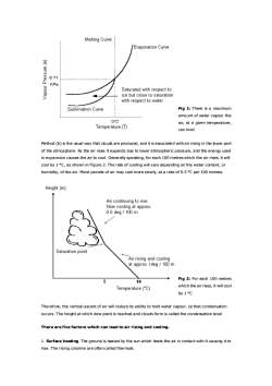
Melting CurveJEvaporationCurve(a)nssadnoden6.11hPaSaturatedwithrespecttoice but close to saturationwithrespecttowaterFig 1: There is a maximumSublimation Curve-amount of water vapour the0°℃air, at a given temperature,Temperature (T)can holdMethod (b) is the usual way that clouds are produced, and it is associated with air rising in the lower partof the atmosphere. As the air rises itexpands due to lower atmospheric pressure, and the energy usedin expansion causes the air to cool. Generally speaking,foreach 100 metres which the air rises, it willcoolby1oC,asshowninFigure2.Therateofcoolingwillvarydependingonthewatercontent,orhumidity,of theair.Moistparcelsofairmaycoolmoreslowly,atarateofo.5Cper100metres.Height (m)Air continuingto rise.Now coolingat approx.0.5 deg/100mSaturation pointAir rising and coolingatapprox1deg/100mFig 2: For each 100 metres510which the air rises, it will coolTemperature (°C)by 1°℃Therefore,theverticalascentofairwillreduceitsabilitytoholdwatervapour,sothatcondensationoccurs.TheheightatwhichdewpointisreachedandcloudsformiscalledthecondensationlevelTherearefivefactors which can lead to air rising and cooling.1.Surfaceheating.Theground isheatedbythesunwhichheatstheairincontactwithitcausingittorise.Therisingcolumnsareoftencalledthermals
Fig 1: There is a maximum amount of water vapour the air, at a given temperature, can hold Method (b) is the usual way that clouds are produced, and it is associated with air rising in the lower part of the atmosphere. As the air rises it expands due to lower atmospheric pressure, and the energy used in expansion causes the air to cool. Generally speaking, for each 100 metres which the air rises, it will cool by 1 °C, as shown in Figure 2. The rate of cooling will vary depending on the water content, or humidity, of the air. Moist parcels of air may cool more slowly, at a rate of 0.5 °C per 100 metres. Fig 2: For each 100 metres which the air rises, it will cool by 1 °C Therefore, the vertical ascent of air will reduce its ability to hold water vapour, so that condensation occurs. The height at which dew point is reached and clouds form is called the condensation level There are five factors which can lead to air rising and cooling. 1. Surface heating. The ground is heated by the sun which heats the air in contact with it causing it to rise. The rising columns are often called thermals
2.Topography.Airforced to rise over a barrier of mountains or hills.This is known as orographic uplift.3. Frontal.A mass of warmair rising up over a mass of cold, denseair.The boundary is calleda front.4.Convergence.Streams of airflowing from different directions are forced to rise where theymeet.5. Turbulence. A sudden change in wind speed with height creating turbulent eddies in the air.Another importantfactorto consider is that watervapourneeds something to condenseonto.Floating intheairaremillionsofminutesalt,dustandsmokeparticlesknownascondensationnucleiwhichenablecondensation totakeplacewhen theairis justsaturated.Typesof cloudsIn1803a retail chemistandamateurmeteorologist called Luke Howard proposed a system which hassubsequently become the basis of the present internationalclassification. Howard also become known bysome people as "the father of British meteorology",and his pioneering work stemmed from his curiousityintothevividsunsetsinthelate18thcenturyfollowingaseriesofviolentvolcaniceruptions.Theyhadejected dust high up into the atmosphere,thereby increasing the amount of condensation nuclei,andproducingspectacularcloudformationsand sunsets.Howard recognisedfourtypes ofcloud andgave them thefollowing Latin names:Cumulus heaped or in a pileStratus-in a sheetor layerCirrus - thread-like, hairy or curledNimbus-a rainbearerIf we includeanother Latin word altummeaningheight,thenames of the ten maincloudtypesareallderivedfromthesefivewordsandbasedupontheirappearancefromgroundlevelandvisualcharacteristics.The cloud types are split into threegroupsaccording to the height of their base abovemean sea level.Note that'medium'level clouds are prefixed by the word alto and'high'clouds by the word cirro (seeTable1).Allheightsgivenareapproximateabovesealevelinmid-latitudes.Ifobservingfromahilltopormountainsite,therangeofbaseswillaccordinglybelower.LowcloudsMedium cloudsHigh cloudsSurface-7,000ft7,000-17,000ft17,000-35,000ftCumulusAltocumulusCirrusCumulonimbusAltostratusCirrostratus
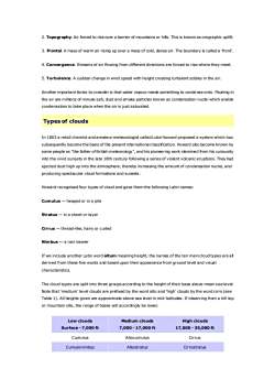
2. Topography. Air forced to rise over a barrier of mountains or hills. This is known as orographic uplift. 3. Frontal. A mass of warm air rising up over a mass of cold, dense air. The boundary is called a 'front'. 4. Convergence. Streams of air flowing from different directions are forced to rise where they meet. 5. Turbulence. A sudden change in wind speed with height creating turbulent eddies in the air. Another important factor to consider is that water vapour needs something to condense onto. Floating in the air are millions of minute salt, dust and smoke particles known as condensation nuclei which enable condensation to take place when the air is just saturated. Types of clouds In 1803 a retail chemist and amateur meteorologist called Luke Howard proposed a system which has subsequently become the basis of the present international classification. Howard also become known by some people as "the father of British meteorology", and his pioneering work stemmed from his curiousity into the vivid sunsets in the late 18th century following a series of violent volcanic eruptions. They had ejected dust high up into the atmosphere, thereby increasing the amount of condensation nuclei, and producing spectacular cloud formations and sunsets. Howard recognised four types of cloud and gave them the following Latin names: Cumulus — heaped or in a pile Stratus — in a sheet or layer Cirrus — thread-like, hairy or curled Nimbus — a rain bearer If we include another Latin word altum meaning height, the names of the ten main cloud types are all derived from these five words and based upon their appearance from ground level and visual characteristics. The cloud types are split into three groups according to the height of their base above mean sea level. Note that 'medium' level clouds are prefixed by the word alto and 'high' clouds by the word cirro (see Table 1). All heights given are approximate above sea level in mid-latitudes. If observing from a hill top or mountain site, the range of bases will accordingly be lower. Low clouds Surface - 7,000 ft Medium clouds 7,000 - 17,000 ft High clouds 17,000 - 35,000 ft Cumulus Altocumulus Cirrus Cumulonimbus Altostratus Cirrostratus
StratusNimbostratusCirrocumulusStratocumulusTable1:The10maincloudtypesLow cloudsCumulus(Cu)Heightofbase:1,200-6,000ftColour: White on its sunlit parts but with darker undersides.Shape:This cloud appears in the form of detached heaps.Shallow cumulusmayappear quite ragged,especiallyin strongwinds,butwellfomed clouds haveflattenedbases andsharpoutlines.Largecumulus clouds have a distinctive"cauliflower'shape.Otherfeatures:Well developed cumulusmayproduce showers.Fig3:Cumulusphoto CrownCumulonimbus(Cb)Heightof base:1,000-5,000ftColour: White upper parts with dark, threatening undersides.Shape: A cumulus-type cloud of considerable vertical extent. When the top of a cumulus reaches greatheights, the water droplets are transformed into ice crystals and it loses its clear,sharp outline. At thisstage the cloud has become a cumulonimbus. Often, the fibrous cloud top spreads out into a distinctivewedge oranvil shape.Otherfeatures:Accompaniedbyheavyshowers,perhapswithhailandthunder.ByconventionCbisusuallyreportedif hail orthunderoccur,eveniftheobserverdoesnotimmediatelyrecognisethecloudas Cb; (itmay be embedded within layers of other cloud types)
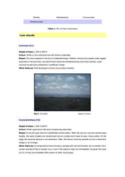
Stratus Nimbostratus Cirrocumulus Stratocumulus Table 1: The 10 main cloud types Low clouds Cumulus (Cu) Height of base: 1,200–6,000 ft Colour: White on its sunlit parts but with darker undersides. Shape: This cloud appears in the form of detached heaps. Shallow cumulus may appear quite ragged, especially in strong winds, but well formed clouds have flattened bases and sharp outlines. Large cumulus clouds have a distinctive "cauliflower" shape. Other features: Well developed cumulus may produce showers. Fig 3: Cumulus photo © Crown Cumulonimbus (Cb) Height of base: 1,000–5,000 ft Colour: White upper parts with dark, threatening undersides. Shape: A cumulus-type cloud of considerable vertical extent. When the top of a cumulus reaches great heights, the water droplets are transformed into ice crystals and it loses its clear, sharp outline. At this stage the cloud has become a cumulonimbus. Often, the fibrous cloud top spreads out into a distinctive wedge or anvil shape. Other features: Accompanied by heavy showers, perhaps with hail and thunder. By convention Cb is usually reported if hail or thunder occur, even if the observer does not immediately recognise the cloud as Cb; (it may be embedded within layers of other cloud types)
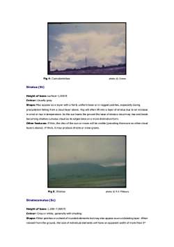
Fig4:Cumulonimbusphoto CrownStratus(St)Heightofbase:surface-1,500ftColour: Usually grey.Shape: May appearas a layer with a fairly uniform base or in ragged patches, especially duringprecipitation falling from a cloud layer above.Fog will often lift into a layer of stratus due to an increasein wind or rise in temperature.As the sun heats the ground the base ofstratus cloudmay riseand breakbecomingshallowcumuluscloudasitsedgestakeonamoredistinctiveformOtherfeatures:Ifthin,thediscofthesunormoonwillbevisible(providingtherearenoothercloudlayersabove).Ifthick, itmayproducedrizzleorsnowgrains.Fig5:Stratusphoto @ R K PilsburyStratocumulus(Sc)Heightofbase:1,200-7,000ftColour:Greyorwhite, generallywithshadingShape: Eitherpatches ora sheetof roundedelements butmayalso appearas an undulating layer.Whenviewedfromtheground,thesizeofindividualelementswillhaveanapparentwidthofmorethan5o
Fig 4: Cumulonimbus photo © Crown Stratus (St) Height of base: surface–1,500 ft Colour: Usually grey. Shape: May appear as a layer with a fairly uniform base or in ragged patches, especially during precipitation falling from a cloud layer above. Fog will often lift into a layer of stratus due to an increase in wind or rise in temperature. As the sun heats the ground the base of stratus cloud may rise and break becoming shallow cumulus cloud as its edges take on a more distinctive form. Other features: If thin, the disc of the sun or moon will be visible (providing there are no other cloud layers above). If thick, it may produce drizzle or snow grains. Fig 5: Stratus photo © R K Pilsbury Stratocumulus (Sc) Height of base: 1,200–7,000 ft Colour: Grey or white, generally with shading. Shape: Either patches or a sheet of rounded elements but may also appear as an undulating layer. When viewed from the ground, the size of individual elements will have an apparent width of more than 5°
when atan elevationgreaterthan30(thewidthof3fingersatarm's length)Otherfeatures:Mayproducelightrain orsnow.Sometimes thecloudmay resultfromthespreadingoutof cumulus, givinga lightshower.Fig6:StratocumulusphotoSDBurtMediumcloudsAltocumulus(Ac)Heightofbase:7,000-17,000ftColour: Grey or white, generally with some shading.Shape:Severaldifferenttypes,themostcommonbeingeitherpatchesorasheetofroundedelementsbut may also appear as a layer without much form. When viewed from the ground, the size of individualelements will havean apparent width of 1 to 5°when at an elevationgreater than 30° (the width of 1 to3 fingers atarm's length).Even if the elements appear smallerthan this the cloud is stll classifiedaltocumulus if it shows shading.Other features: Occasionally some slight rain or snow, perhaps in the form of a showermay reach theground. On rare occasions, a thunderstorm may occur from onetype of Acknown as altocumuluscastellanus so called because in outline, the cloud tops look like a series ofturrets and towers along acastle wall
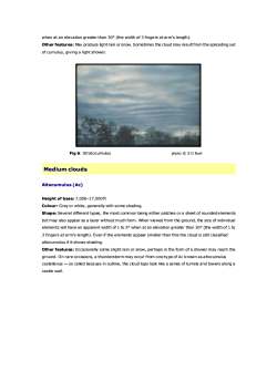
when at an elevation greater than 30° (the width of 3 fingers at arm's length). Other features: May produce light rain or snow. Sometimes the cloud may result from the spreading out of cumulus, giving a light shower. Fig 6: Stratocumulus photo © S D Burt Medium clouds Altocumulus (Ac) Height of base: 7,000–17,000 ft Colour: Grey or white, generally with some shading. Shape: Several different types, the most common being either patches or a sheet of rounded elements but may also appear as a layer without much form. When viewed from the ground, the size of individual elements will have an apparent width of 1 to 5° when at an elevation greater than 30° (the width of 1 to 3 fingers at arm's length). Even if the elements appear smaller than this the cloud is still classified altocumulus if it shows shading. Other features: Occasionally some slight rain or snow, perhaps in the form of a shower may reach the ground. On rare occasions, a thunderstorm may occur from one type of Ac known as altocumulus castellanus — so called because in outline, the cloud tops look like a series of turrets and towers along a castle wall
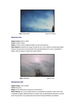
Fig 7:Altocumulusphoto R K PilsburyAltostratus(As)Heightofbase:8,000-17,000ftColour:Greyishorbluish.Shape:Asheetofuniformappearancetotallyorpartlycovering thesky.Otherfeatures:Sometimes thin enough to reveal the sun ormoon vaguely,as through groundglass.Objectson thegrounddonotcast shadows.Maygivegenerally lightrainorsnow,occasionally icepellets, if the cloud base is no higherthan about 10,000 ft.Fig 8: Altostratusphoto CrownNimbostratus(Ns)Heightofbase:1,500-10,000ftColour: Dark grey.Shape: A thick, diffuse layer covering all ormost of the sky.Otherfeatures:Sun or moonalwaysblottedout.Accompanied by moderate or heavy rain or snow,occasionally ice pellets. Although classed as a medium cloud, its base frequently descends to low cloudlevels.Maybepartlyoreventotallyobscuredbystratusfomingunderneathinprecipitation
Fig 7: Altocumulus photo © R K Pilsbury Altostratus (As) Height of base: 8,000–17,000 ft Colour: Greyish or bluish. Shape: A sheet of uniform appearance totally or partly covering the sky. Other features: Sometimes thin enough to reveal the sun or moon vaguely, as through ground glass. Objects on the ground do not cast shadows. May give generally light rain or snow, occasionally ice pellets, if the cloud base is no higher than about 10,000 ft. Fig 8: Altostratus photo © Crown Nimbostratus (Ns) Height of base: 1,500–10,000 ft Colour: Dark grey. Shape: A thick, diffuse layer covering all or most of the sky. Other features: Sun or moon always blotted out. Accompanied by moderate or heavy rain or snow, occasionally ice pellets. Although classed as a medium cloud, its base frequently descends to low cloud levels. May be partly or even totally obscured by stratus forming underneath in precipitation
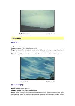
Fig9:Nimbostratusphoto S D BurtHighcloudsCirrus (Ci)Heightofbase:17,000-35,000ftColour:Composedof icecrystals,thereforewhiteShape: Delicate hair-like filaments, sometimes hooked at the end; or in denser, entangled patches; oroccasionally in parallel bands which appear to converge towards the horizon.Other features: The remains of the upper portion of a cumulonimbus is also classified as cirrus.Fig 10:Cirrusphoto SDBurtCirrocumulus (Cc)Heightofbase:17,000-35,000ftColour:Composed of icecrystals,thereforewhite.Shape: Patches or sheet of very small elements in the form of grains or ripples ora honeycomb.Whenviewed from the ground, the size of individualelements will have an apparent width of less than 1 when
Fig 9: Nimbostratus photo © S D Burt High clouds Cirrus (Ci) Height of base: 17,000–35,000 ft Colour: Composed of ice crystals, therefore white. Shape: Delicate hair-like filaments, sometimes hooked at the end; or in denser, entangled patches; or occasionally in parallel bands which appear to converge towards the horizon. Other features: The remains of the upper portion of a cumulonimbus is also classified as cirrus. Fig 10: Cirrus photo © S D Burt Cirrocumulus (Cc) Height of base: 17,000–35,000 ft Colour: Composed of ice crystals, therefore white. Shape: Patches or sheet of very small elements in the form of grains or ripples or a honeycomb. When viewed from the ground, the size of individual elements will have an apparent width of less than 1° when
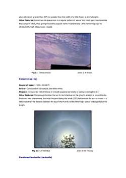
atan elevation greater than 30o (no greaterthan the width of a littlefinger at arm's length).Otherfeatures:Sometimes its appearance in aregularpattern of'waves'andsmall gapsmayresemblethe scales of a fish, thus giving rise to the popular name 'mackerel sky. (this name may also beattributed to highaltocumulus clouds),Fig11:CirrocumulusphotoMBrooksCirrostratus(Cs)Heightofbase:17,000-35,000ftColour:Composedoficecrystals,thereforewhiteShape:Atransparent veil of fibrous or smoothappearancetotallyorpartlycovering the sky.Otherfeatures:Thinenough to allowthe sun to castshadows on theground unless it is low in the sky.Produceshalophenomena,themostfrequentbeingthesmall(22)haloaroundthesunormoon-alittle more than thedistance between the top of the thumband the littlefinger spread wide apartat arm'slength.Fig 12:Cirrostratusphoto @RK PilsburyCondensationtrails(contrails)
at an elevation greater than 30° (no greater than the width of a little finger at arm's length). Other features:Sometimes its appearance in a regular pattern of 'waves' and small gaps may resemble the scales of a fish, thus giving rise to the popular name 'mackerel sky'. (this name may also be attributed to high altocumulus clouds). Fig 11: Cirrocumulus photo © M Brooks Cirrostratus (Cs) Height of base: 17,000–35,000 ft Colour: Composed of ice crystals, therefore white. Shape: A transparent veil of fibrous or smooth appearance totally or partly covering the sky. Other features: Thin enough to allow the sun to cast shadows on the ground unless it is low in the sky. Produces halo phenomena, the most frequent being the small (22°) halo around the sun or moon — a little more than the distance between the top of the thumb and the little finger spread wide apart at arm's length. Fig 12: Cirrostratus photo © RK Pilsbury Condensation trails (contrails)
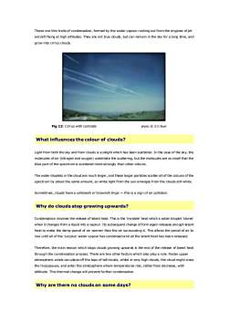
These are thin trails of condensation,formed by thewater vapourrushing out from the engines ofjetaircraft flying at high altitudes.They are not true clouds, but can remain in the sky for a long time, andgrow into cirrus cloudsFig 13: Cirrus with contrailsphotoSDBurtWhatinfluencesthecolourof clouds?Light from both the sky and from clouds is sunlight which has been scattered. In the case of the sky, themoleculesofair(nitrogenandoxygen)undertakethescattering,butthemoleculesaresosmallthattheblue part of the spectrum is scattered more strongly than other colours.Thewaterdropletsinthecloudaremuchlarger,andtheselargerparticlesscatterallofthecoloursofthespectrum by about the same amount, so white light from the sun emerges from the clouds still white.Sometimes, clouds havea yellowish or brownish tinge-this is a sign of air pollution.Why do cloudsstop growingupwards?Condensation involves the release of latent heat.This is the'invisible'heat whicha water droplet'stores'when itchangesfrom a liquid into avapour.Its subsequentchangeofformagain releases enoughlatentheatto make thedamp parcel of air warmer than theair surrounding it.This allows the parcelof air toriseuntil all ofthe'surplus'water vapour has condensedand all the latent heat has been released.Therefore, themain reason which stops clouds growing upwards is the end of the release of latent heatthrough the condensation process.There are two otherfactors which also playa role.Faster upperatmospheric winds can plane off the tops of tall clouds, whilst in very high clouds, the cloud might crossthe tropopause, and enter the stratosphere where temperatures rise, rather than decrease, withaltitiude.This thermal change will prevent furthercondensation.Whyarethereno cloudsonsome days?
These are thin trails of condensation, formed by the water vapour rushing out from the engines of jet aircraft flying at high altitudes. They are not true clouds, but can remain in the sky for a long time, and grow into cirrus clouds. Fig 13: Cirrus with contrails photo © S D Burt What influences the colour of clouds? Light from both the sky and from clouds is sunlight which has been scattered. In the case of the sky, the molecules of air (nitrogen and oxygen) undertake the scattering, but the molecules are so small that the blue part of the spectrum is scattered more strongly than other colours. The water droplets in the cloud are much larger, and these larger particles scatter all of the colours of the spectrum by about the same amount, so white light from the sun emerges from the clouds still white. Sometimes, clouds have a yellowish or brownish tinge — this is a sign of air pollution. Why do clouds stop growing upwards? Condensation involves the release of latent heat. This is the 'invisible' heat which a water droplet 'stores' when it changes from a liquid into a vapour. Its subsequent change of form again releases enough latent heat to make the damp parcel of air warmer than the air surrounding it. This allows the parcel of air to rise until all of the 'surplus' water vapour has condensed and all the latent heat has been released. Therefore, the main reason which stops clouds growing upwards is the end of the release of latent heat through the condensation process. There are two other factors which also play a role. Faster upper atmospheric winds can plane off the tops of tall clouds, whilst in very high clouds, the cloud might cross the tropopause, and enter the stratosphere where temperatures rise, rather than decrease, with altitiude. This thermal change will prevent further condensation. Why are there no clouds on some days?
按次数下载不扣除下载券;
注册用户24小时内重复下载只扣除一次;
顺序:VIP每日次数-->可用次数-->下载券;
- 《农业气象学》课程教学资源(文献资料)Air masses.doc
- 《农业气象学》课程教学资源(文献资料)Agrometeorology.doc
- 《农业气象学》课程教学资源(文献资料)The atmosphere.doc
- 《农业气象学》课程教学资源(文献资料)Thunderstorms.doc
- 《农业气象学》课程教学资源(文献资料)Weather forecasting.doc
- 《农业气象学》课程教学资源(文献资料)Clouds 2/2.doc
- 《农业气象学》课程授课教案(石河子大学:胡晓棠).doc
- 《农业气象学》课程教学大纲(农学院各类专业用).pdf
- 《农业信息技术》课程教学课件(讲稿)第二章 精准农业技术.pdf
- 《农业信息技术》课程教学课件(讲稿)第四章 遥感技术.pdf
- 《农业信息技术》课程教学课件(讲稿)第一章 绪论.pdf
- 《农业信息技术》课程教学课件(讲稿)第三章 全球定位系统与应用(Global Positioning System,GPS).pdf
- 《农业信息技术》课程教学课件(讲稿)第七章 作物模拟模型.pdf
- 《农业信息技术》课程教学课件(讲稿)第八章 农业专家系统.pdf
- 《农业信息技术》课程教学课件(讲稿)第六章 决策支持系统.pdf
- 《农业信息技术》课程教学课件(讲稿)第五章 地理信息系统.pdf
- 《农业信息技术》课程授课教案(石河子大学:蒋桂英).pdf
- 《农业信息技术》课程教学资源(讲义,共八章).pdf
- 《农业信息技术》课程教学大纲 Agricultural Information Technology.pdf
- 《种子生产学》课程教学资源(文献资料)水稻的一生.doc
- 《农业气象学》课程教学课件(PPT讲稿)第四章 大气中的水分.ppt
- 《农业气象学》课程教学课件(PPT讲稿)第五章 气压与风.ppt
- 《农业气象学》课程教学课件(PPT讲稿)第三章 热量.ppt
- 《农业气象学》课程教学课件(PPT讲稿)第二章 辐射.ppt
- 《农业气象学》课程教学课件(PPT讲稿)第六章 天气及农业气象灾害.ppt
- 《农业气象学》课程教学课件(PPT讲稿)第一章 大气.ppt
- 《农业气象学》课程教学课件(PPT讲稿)第七章 气候与农业气候.ppt
- 《耕作学》课程教学大纲 Farming System(农学专业).docx
- 《耕作学》课程考试大纲 Testing Principle Farming System.pdf
- 《耕作学》课程授课教案(石河子大学:刘建国).doc
- 《耕作学》课程课程习题集(含参考答案).doc
- 《耕作学》课程教学资源(PPT课件)第十章 耕作制度发展与趋势展望.ppt
- 《耕作学》课程教学资源(PPT课件)第十一章 信息技术在现代农业中的应用.ppt
- 《耕作学》课程教学资源(PPT课件)第九章 土壤耕作 Soil Tillage.ppt
- 《耕作学》课程教学资源(PPT课件)第八章 农田养护 Conservation of crop land.ppt
- 《耕作学》课程教学资源(PPT课件)第六章 轮作与连作.ppt
- 《耕作学》课程教学资源(PPT课件)第七章 农牧结合的种植制度.ppt
- 《耕作学》课程教学资源(PPT课件)第四章 复种.ppt
- 《耕作学》课程教学资源(PPT课件)第十章 双语教学 The Evolvemental history, present state and Perspective of Farming system.ppt
- 《耕作学》课程教学资源(PPT课件)第五章 间、混、套作.ppt
