《地质与地貌学》课程教学资源(PPT课件)第十二章 海岸地貌和湖泊地貌 Coastal Landforms and Lake Landforms
Chapter 12 Coastal Landforms and Lake Landforms
Chapter 12 Coastal Landforms and Lake Landforms
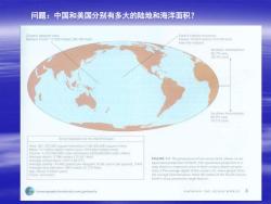
问题:中国和美国分别有多大的陆地和海洋面积? Ocean's deepest spot Earths highest mounti作 Mariana Trenich 11.022 metors (36.163 leet) Hawail 10.203 meters (33 476 tat) from the seabed Notthem Hemisphere 06G 393%1ad Some Statisticn for the Warld Ocean Aroa 361 100.000 square kilometers (139,400.000 square miles) Masa:14t billion billion metric tons (155 billion billiion torn) Volume 1,370,000,000 cubic kilometers (329,000,000 cutic miles) Average depth 3.796 metor (12 451 teer) Average tomnperaturo 3.9C (99.0F FIGURE 1.2 The proportion of sea versus land,shown on an Average salmty 34.482 grams por lolpgram (0.56 ounce per pound)3.4% cqual-area projection of Earth (An equal area projecton s Average land elvation 840 meters (2.772 leet) map drawn to represent areas in their correct relative propor Ape:About 4 billion yoar tions.The average depth of the ocean is 4 times greater than Fufure Uncertain the averave land clevation Note the exent of the Pacinie Ocean. Earth's most prominent single feature //oceanography.brooksrole.com/garisonse KNOWING THE OCEAN WORLD 3
问题:中国和美国分别有多大的陆地和海洋面积?
Oceanography Early Voyaging Trade in the Mediterranean Sea,the Cretans or the Phoenicians Science for Voyaging The Library of Alexandria in Egypt founded in the third century B.C. Chinese Contributions The Age of Discovery:From Prince Henry to Magellan
Early Voyaging Trade in the Mediterranean Sea, the Cretans or the Phoenicians Science for Voyaging The Library of Alexandria in Egypt founded in the third century B.C. Chinese Contributions Oceanography The Age of Discovery: From Prince Henry to Magellan
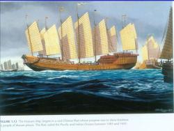
IGURE 1.13 The treasure ship,largest in a vast Chinese fleet whose purpose was to show kindness o people of distant places.The fleet sailed the Pacific and Indian Oceans between 1405 and 1433
Between 1405 and 1433 Admiral Zheng He commanded the greatest fleet the world -had ever known.At least 317 ships and 37,000 men undertook seven missions to explore oceans.Their aim:to display the wealth and power of the Ming dynasty and to show kindness to people of distant places.The largest ship in the fleet with a length of 134 meters was a huge treasure ship carrying objects of the finest materials and craftmanship.The mission of the fleet was not to accumulate such treasure but to give it away
▪ Between 1405 and 1433 Admiral Zheng He commanded the greatest fleet the world ▪ had ever known. At least 317 ships and 37,000 men undertook seven missions to explore oceans. Their aim: to display the wealth and power of the Ming dynasty and to show kindness to people of distant places. The largest ship in the fleet with a length of 134 meters was a huge treasure ship carrying objects of the finest materials and craftmanship. The mission of the fleet was not to accumulate such treasure but to give it away
Despite enjoying these technical advances. the Chinese intentionally abandoned oceanic exploration in 1433.The political winds had changed,and the cost of the “reverse tribute”system was judged too great.In all,until late in the twentieth century, the Chinese made very few contributions to our understanding of the the ocean.Still, their voyaging technology filtered into the West and made subsequent discoveries possible
▪ Despite enjoying these technical advances, the Chinese intentionally abandoned oceanic exploration in 1433. The political winds had changed, and the cost of the “reverse tribute” system was judged too great. In all, until late in the twentieth century, the Chinese made very few contributions to our understanding of the the ocean. Still, their voyaging technology filtered into the West and made subsequent discoveries possible

Prince Henry established a center of marine science in the mid-1400s 150co0r1520 /anography-bruoscolecom/n 0 FIGURE 1.16 (a)Ferdinand Magellin,a Portuguese navigator in serv ice to Spain whose expedition was first to circumnavigate the world (b)Track of the Magellan expedition,the first voyage aruund the world. Magellan himself did not survive the voyage;only 34 out of 260 sailors managed to retum after three years of dangerous travel
Prince Henry established a center of marine science in the mid-1400s
Laws of the Sea 1703,a country's seaward boundary was set at about 5 km. -In April 1982,the United Nations adopted the convention by a vote of 130 to 4,with 17 abstentions. -Territorial waters 12 miles from shore. A nation has the right to jurisdiction Exclusive economic zone (EEZ)370km from shoreline.Nations hold sovereignty over resources,economic activities. -High seas outside the EEZs
Laws of the Sea ▪ 1703, a country’s seaward boundary was set at about 5 km. ▪ In April 1982, the United Nations adopted the convention by a vote of 130 to 4, with 17 abstentions. ▪ Territorial waters 12 miles from shore. A nation has the right to jurisdiction ▪ Exclusive economic zone (EEZ) 370km from shoreline. Nations hold sovereignty over resources, economic activities. ▪ High seas outside the EEZs
·中国国家海洋局(青岛海洋所,厦门海洋所,杭 州海洋所) ·中国科学院海洋研究所,广州海洋所 ·同济大学 华东师范大学 ·青岛海洋大学
▪ 中国国家海洋局 (青岛海洋所,厦门海洋所,杭 州海洋所) ▪ 中国科学院海洋研究所,广州海洋所 ▪ 同济大学 ▪ 华东师范大学 ▪ 青岛海洋大学
第一节海岸地貌 12.1 Coastal Landforms
第一节 海岸地貌 12.1 Coastal Landforms
按次数下载不扣除下载券;
注册用户24小时内重复下载只扣除一次;
顺序:VIP每日次数-->可用次数-->下载券;
- 《地质与地貌学》课程教学资源(PPT课件)第十一章 冰川地貌与冻土地貌 Glacial Landforms and Periglacial Landforms.ppt
- 《地质与地貌学》课程教学资源(PPT课件)第八章 地下水 Groundwater、岩溶地貌 Karst Landforms.ppt
- 《地质与地貌学》课程教学资源(PPT课件)第十三章 地质环境与地质灾害 Geological Environment and Geological Disasters.ppt
- 《地质与地貌学》课程教学资源(PPT课件)第十章 黄土地貌 Loess Landforms.ppt
- 《地质与地貌学》课程教学资源(PPT课件)第五章 风化作用 Weathering.ppt
- 《地质与地貌学》课程教学资源(PPT课件)第九章 风成地貌 Landforms Formed by Winds.ppt
- 《地质与地貌学》课程教学资源(PPT课件)第七章 流水地貌及堆积物 Landforms Formed by Running Water and Accumulation.ppt
- 《地质与地貌学》课程教学资源(PPT课件)第六章 斜坡地貌 Landforms on Slopes.ppt
- 《地质与地貌学》课程教学资源(PPT课件)第一章 矿物 Minerals.ppt
- 《地质与地貌学》课程教学资源(PPT课件)第二章 岩石 Rocks.ppt
- 《地质与地貌学》课程教学资源(PPT课件)第四章 构造运动与地质构造 Tectonic Movement and Geological Structure.ppt
- 《地质与地貌学》课程教学资源(PPT课件)第三章 地质年代与地质发展史 Geologic Time and History.ppt
- 《地质与地貌学》课程教学资源(PPT课件)绪论 Geology and Geomorphology.ppt
- 《地质与地貌学》课程期末考试试题(A卷-答案).doc
- 《地质与地貌学》课程期末考试试题(A卷-题目).doc
- 《地质与地貌学》课程模拟试题(答案).doc
- 《地质与地貌学》课程教学实验指导(共九个实验).doc
- 《地质与地貌学》课程模拟试题(题目).doc
- 《地质与地貌学》课程授课教案(讲义,共十三章).doc
- 《地质与地貌学》课程教学大纲(Geology and Geomorphology).pdf
- 《地理信息系统》课程教学大纲 Geographical Information System.doc
- 《地理信息系统》课程授课教案21.docx
- 《地理信息系统》课程授课教案22.docx
- 《地理信息系统》课程授课教案24.docx
- 《地理信息系统》课程授课教案23.docx
- 《地理信息系统》课程授课教案20.docx
- 《地理信息系统》课程授课教案18.docx
- 《地理信息系统》课程授课教案19.docx
- 《地理信息系统》课程授课教案17.docx
- 《地理信息系统》课程授课教案15.docx
- 《地理信息系统》课程授课教案12.docx
- 《地理信息系统》课程授课教案16.docx
- 《地理信息系统》课程授课教案13.docx
- 《地理信息系统》课程授课教案10.docx
- 《地理信息系统》课程授课教案11.docx
- 《地理信息系统》课程授课教案09.docx
- 《地理信息系统》课程授课教案08.doc
- 《地理信息系统》课程授课教案04.doc
- 《地理信息系统》课程授课教案06.doc
- 《地理信息系统》课程授课教案05.doc
