电子科技大学:《遥感图像处理 Remote Sensing Image Processing》课程教学资源(课件讲稿)第七章 遥感图像分类

第七章 P R 遥感图像分类 1
1 第七章 遥感图像分类 UESTC-RSIP

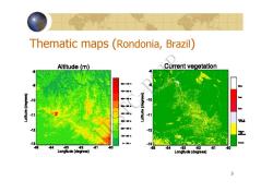
专题分类 A thematic map shows the spatial distribution of identifiable earth surface features;it provides an informational description over a given area,rather than a data description. Image classification is the process used to produce thematic maps from imagery.The themes can range, for example,from categories such as soil,vegetation, and surface water in a general description of a rural area,to different types of soil,vegetation,and water depth or clarity for a more detailed description. 2
2 专题分类 A thematic map shows the spatial distribution of identifiable earth surface features; it provides an informational description over a given area, rather than a data description. Image classification is the process used to produce thematic maps from imagery. The themes can range, for example, from categories such as soil, vegetation, and surface water in a general description of a rural area, to different types of soil, vegetation, and water depth or clarity for a more detailed description. UESTC-RSIP

Thematic maps (Rondonia,Brazil) Altitude(m) Current vegetation 8 10 11 .11 12 -12 -13 -13 -54 -83 62 51 80 86 84 -63 -62 61 60 Longttude (degrees) Longttude (degrees) 3
3 Thematic maps (Rondonia, Brazil ) UESTC-RSIP

Soil -8 Clay (med)% 10 -12 000WS00000 -12 : -13 6 64 -63 82 81 60 -13 no data Longtuda (degrees) 64 -63 2 81 Longituda (dagroas) 4
4 UESTC-RSIP

Sand (med)% Vegetation 80 0 -10 11 -12 0 -13 no 13 dat 50 86 84 -8g 82 81 80 84 -63 62 81 Longitude (dogresa) Longttuda (decrees) 5
5 UESTC-RSIP

40 00 NORTH OCEAN NORTH ATLANT Troolc of Cancer Tropic of Caoricarn U PACIRC OCEA Antarctic Circle Soil Types Alfisols:gray to brown surtace soils, Inceptisols:weaky developed immature soils, Uissols:acidic and clayey soils of upland tropical medium to high base nutrients and organic content typically tundra or volcanic soils savannas:medium base nutrients Andisols:dry or desert soils:high in Mollisols:thick.dark soils of tallgrass praines; Vertisois:clay soils of moist tropical savannas: base nutrients and low in organic content high in organic content and base nutrients tend to crack and swell when dry Entisols:soils with poorty deveioped layers Oxisols:tropical and subtropical highly Mountain sois:thin sois,tending toward acidic: typically wind-deposited soils weathered soils:low in organic and base nutrients miced vareties based on vertical zonation Histosols:swamps and bog soits:wet,highly L相a or no soil orgsnic (peat and muck)content high in organic content and low in base nutrients
6 UESTC-RSIP

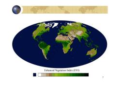
Enhanced Vegetation Index(EVI) 7
7 Enhanced Vegetation Index (EVI) UESTC-RSIP

人工解译航片 730 217a Tabor Dake 2172X Tabor Lake 9171 主要依赖的地物属性有:形状、纹理、地物之间的相关性、颜色等 8
8 人工解译航片 主要依赖的地物属性有:形状、纹理、地物之间的相关性、颜色等 UESTC-RSIP

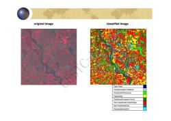
original image classified image Open Water Woody/Emergent Wetlands Grasslands/Herbaceous Pasture/Hay Deciduous/Evergreen Forest Row Crops/Small Grains/Fallow Bare Rock/Sand/Clay ResidentiaVIndustria
9 original image classified image Pasture/Hay Grasslands/Herbaceous Woody/Emergent Wetlands Open Water Residential/Industrial Bare Rock/Sand/Clay Row Crops/Small Grains/Fallow Deciduous/Evergreen Forest UESTC-RSIP

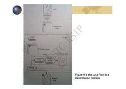
scene atmosphere sensor multispectral image classifer extraction 1 K-D feature image TC training K-D feature space determine select decision training pirels boundaries labeling Figure 9-1 the data flow in a b thematic classification process map
Figure 9-1 the data flow in a classification process UESTC-RSIP
按次数下载不扣除下载券;
注册用户24小时内重复下载只扣除一次;
顺序:VIP每日次数-->可用次数-->下载券;
- 电子科技大学:《遥感图像处理 Remote Sensing Image Processing》课程教学资源(课件讲稿)第四章 遥感图像的空域与频域变换.pdf
- 电子科技大学:《遥感图像处理 Remote Sensing Image Processing》课程教学资源(课件讲稿)第五章 遥感图像的校正与定标.pdf
- 电子科技大学:《遥感图像处理 Remote Sensing Image Processing》课程教学资源(课件讲稿)第一章 遥感图像处理基础(陈奋).pdf
- 中国地质大学(武汉):测控技术与仪器专业本科培养方案.pdf
- 上海交通大学:《现代测绘技术》课程教学资源(电子教案)测量误差的基本知识(周拥军).doc
- 西安石油大学:《虚拟仪器》课程教学资源(电子课件,打印版)第四章 虚拟仪器硬件模块驱动程序的设计方法.pdf
- 西安石油大学:《虚拟仪器》课程教学资源(电子课件,打印版)第五章 虚拟仪器软件平台介绍.pdf
- 西安石油大学:《虚拟仪器》课程教学资源(电子课件,打印版)第二章 信号调理与采集 signal conditioning and Acquisition.pdf
- 西安石油大学:《虚拟仪器》课程教学资源(电子课件,打印版)第三章 虚拟仪器系统总线接口技术.pdf
- 西安石油大学:《虚拟仪器》课程教学资源(电子课件,打印版)第一章 虚拟仪器概论(贾惠芹).pdf
- 西安石油大学:《虚拟仪器》课程教学资源_电子教案(打印版).pdf
- 广东工业大学建设学院:《交通土木工程测量》(修订版)电子教案_第四章 高程测量.pps
- 滁州学院:《遥感导论》课程电子教案(PPT课件)第二章 电磁辐射与地物波谱特征.ppt
- 《测量学 Engineering Surveying》课程教学资源:课程教学资源:试题库(附答案).pdf
- 《测量学 Engineering Surveying》课程教学资源:实践教学大纲.pdf
- 安徽理工大学:《GPS定位原理与应用》课程教学资源(PPT课件讲稿)第七章 GNSS数据处理简介.ppsx
- 《测量学 Engineering Surveying》课程教学资源:实践教学大纲(工程测量).pdf
- 安徽理工大学:《GPS定位原理与应用》课程教学资源(PPT课件讲稿)第二章 坐标系统和时间系统 Coordinate and Time System.ppsx
- 安徽理工大学:《GPS定位原理与应用》课程教学资源(PPT课件讲稿)第三章 卫星运动基本知识及其坐标计算.ppsx
- 安徽理工大学:《GPS定位原理与应用》课程教学资源(PPT课件讲稿)第六章 GNSS测量的实施.ppsx
- 电子科技大学:《遥感图像处理 Remote Sensing Image Processing》课程教学资源(课件讲稿)第二章 遥感图像数据模型.pdf
- 电子科技大学:《遥感图像处理 Remote Sensing Image Processing》课程教学资源(课件讲稿)第六章 遥感图像的配准与融合.pdf
- 电子科技大学:《遥感图像处理 Remote Sensing Image Processing》课程教学资源(课件讲稿)第三章 光谱变换.pdf
- 电子科技大学:《定量遥感》课程教学大纲 Quantative Remote Sensing(主讲:何彬彬).pdf
- 电子科技大学:《定量遥感》课程教学资源(课件讲稿)第1章 绪论 1.1 遥感科学及其研究范畴.pdf
- 电子科技大学:《定量遥感》课程教学资源(课件讲稿)第1章 绪论 1.2 定量遥感的基本理论问题.pdf
- 电子科技大学:《定量遥感》课程教学资源(课件讲稿)第1章 绪论 1.3 定量遥感的基本物理概念.pdf
- 电子科技大学:《定量遥感》课程教学资源(课件讲稿)第2章 大气辐射传输模型.pdf
- 电子科技大学:《定量遥感》课程教学资源(课件讲稿)第4章 遥感地表参数反演原理与方法.pdf
- 电子科技大学:《定量遥感》课程教学资源(课件讲稿)第5章 遥感数据同化与地表参数时序模拟.pdf
- 电子科技大学:《定量遥感》课程教学资源(课件讲稿)第6章 遥感地表参数反演专题应用 6.2 植被生物量遥感估算方法.pdf
- 电子科技大学:《定量遥感》课程教学资源(课件讲稿)第6章 遥感地表参数反演专题应用 6.3 基于ACRM模型和查找表算法的高原湿地植被叶面积指数(LAI)反演.pdf
- 电子科技大学:《定量遥感》课程教学资源(课件讲稿)第3章 植被遥感模型.pdf
- 电子科技大学:《定量遥感》课程教学资源(课件讲稿)第6章 遥感地表参数反演专题应用 6.1 基于数据同化思想的时序遥感数据产品质量改进.pdf
- 电子科技大学:《遥感地面数据采集与实验方法 Methods for Remote Sensing Experiment》课程教学资源(教学大纲,周纪).pdf
- 电子科技大学:《遥感地面数据采集与实验方法 Methods for Remote Sensing Experiment》课程教学资源(课件讲稿)实验01 遥感地面实验基础与实验设计.pdf
- 电子科技大学:《遥感地面数据采集与实验方法 Methods for Remote Sensing Experiment》课程教学资源(课件讲稿)实验02 地物反射光谱采集实验.pdf
- 电子科技大学:《遥感地面数据采集与实验方法 Methods for Remote Sensing Experiment》课程教学资源(课件讲稿)实验03 地物辐射参数采集实验.pdf
- 电子科技大学:《遥感地面数据采集与实验方法 Methods for Remote Sensing Experiment》课程教学资源(课件讲稿)实验04 气象参数采集实验.pdf
- 电子科技大学:《遥感地面数据采集与实验方法 Methods for Remote Sensing Experiment》课程教学资源(课件讲稿)实验05 土壤参数采集任务说明.pdf
