电子科技大学:《遥感图像处理 Remote Sensing Image Processing》课程教学资源(课件讲稿)第六章 遥感图像的配准与融合
第六章《 遥感图像的配准与融合 1
1 第六章 遥感图像的配准与融合 UESTC-RSIP
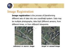
Image Registration Image registration is the process of transforming different sets of data into one coordinate system.Data may be multiple photographs,data from different sensors,from different times,or from different viewpoints. reference or source image target or sensed image
Image Registration Image registration is the process of transforming different sets of data into one coordinate system. Data may be multiple photographs, data from different sensors, from different times, or from different viewpoints. reference or source image target or sensed image UESTC-RSIP
遥感图像重叠区域的产生 同一卫星传感器的重访,或者是同一轨道的, 或者是不同轨道通过侧摆指向同一区域 同一卫星传感器的相邻轨道,它们之间相差 几天 不同卫星传感器 卫星传感器和航空传感器 3
3 遥感图像重叠区域的产生 同一卫星传感器的重访,或者是同一轨道的, 或者是不同轨道通过侧摆指向同一区域 同一卫星传感器的相邻轨道,它们之间相差 几天 不同卫星传感器 卫星传感器和航空传感器 UESTC-RSIP
a b C d
UESTC-RSIP
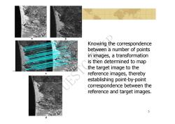
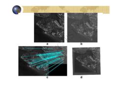
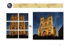
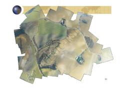
Knowing the correspondence between a number of points in images,a transformation is then determined to map the target image to the G reference images,thereby establishing point-by-point correspondence between the reference and target images. 5
5 Knowing the correspondence between a number of points in images, a transformation is then determined to map the target image to the reference images, thereby establishing point-by-point correspondence between the UESTC-RSIP reference and target images
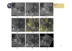
(a) (B) (c) (d) (e) () 6 13 (g) ) ①)
6 UESTC-RSIP
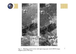
口 00 图 0 Fig.7.Matching results for the sixth input image pair.(Left)SPOT4 image. 7 (Right)Landsat TM image
7 UESTC-RSIP
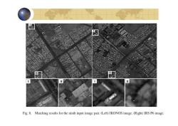
Fig.8.Matching results for the ninth input image pair.(Left)IKONOS image.(Right)IRS P6 image
8 UESTC-RSIP
→ 9
9 UESTC-RSIP
10
10 UESTC-RSIP
按次数下载不扣除下载券;
注册用户24小时内重复下载只扣除一次;
顺序:VIP每日次数-->可用次数-->下载券;
- 电子科技大学:《遥感图像处理 Remote Sensing Image Processing》课程教学资源(课件讲稿)第二章 遥感图像数据模型.pdf
- 电子科技大学:《遥感图像处理 Remote Sensing Image Processing》课程教学资源(课件讲稿)第七章 遥感图像分类.pdf
- 电子科技大学:《遥感图像处理 Remote Sensing Image Processing》课程教学资源(课件讲稿)第四章 遥感图像的空域与频域变换.pdf
- 电子科技大学:《遥感图像处理 Remote Sensing Image Processing》课程教学资源(课件讲稿)第五章 遥感图像的校正与定标.pdf
- 电子科技大学:《遥感图像处理 Remote Sensing Image Processing》课程教学资源(课件讲稿)第一章 遥感图像处理基础(陈奋).pdf
- 中国地质大学(武汉):测控技术与仪器专业本科培养方案.pdf
- 上海交通大学:《现代测绘技术》课程教学资源(电子教案)测量误差的基本知识(周拥军).doc
- 西安石油大学:《虚拟仪器》课程教学资源(电子课件,打印版)第四章 虚拟仪器硬件模块驱动程序的设计方法.pdf
- 西安石油大学:《虚拟仪器》课程教学资源(电子课件,打印版)第五章 虚拟仪器软件平台介绍.pdf
- 西安石油大学:《虚拟仪器》课程教学资源(电子课件,打印版)第二章 信号调理与采集 signal conditioning and Acquisition.pdf
- 西安石油大学:《虚拟仪器》课程教学资源(电子课件,打印版)第三章 虚拟仪器系统总线接口技术.pdf
- 西安石油大学:《虚拟仪器》课程教学资源(电子课件,打印版)第一章 虚拟仪器概论(贾惠芹).pdf
- 西安石油大学:《虚拟仪器》课程教学资源_电子教案(打印版).pdf
- 广东工业大学建设学院:《交通土木工程测量》(修订版)电子教案_第四章 高程测量.pps
- 滁州学院:《遥感导论》课程电子教案(PPT课件)第二章 电磁辐射与地物波谱特征.ppt
- 《测量学 Engineering Surveying》课程教学资源:课程教学资源:试题库(附答案).pdf
- 《测量学 Engineering Surveying》课程教学资源:实践教学大纲.pdf
- 安徽理工大学:《GPS定位原理与应用》课程教学资源(PPT课件讲稿)第七章 GNSS数据处理简介.ppsx
- 《测量学 Engineering Surveying》课程教学资源:实践教学大纲(工程测量).pdf
- 安徽理工大学:《GPS定位原理与应用》课程教学资源(PPT课件讲稿)第二章 坐标系统和时间系统 Coordinate and Time System.ppsx
- 电子科技大学:《遥感图像处理 Remote Sensing Image Processing》课程教学资源(课件讲稿)第三章 光谱变换.pdf
- 电子科技大学:《定量遥感》课程教学大纲 Quantative Remote Sensing(主讲:何彬彬).pdf
- 电子科技大学:《定量遥感》课程教学资源(课件讲稿)第1章 绪论 1.1 遥感科学及其研究范畴.pdf
- 电子科技大学:《定量遥感》课程教学资源(课件讲稿)第1章 绪论 1.2 定量遥感的基本理论问题.pdf
- 电子科技大学:《定量遥感》课程教学资源(课件讲稿)第1章 绪论 1.3 定量遥感的基本物理概念.pdf
- 电子科技大学:《定量遥感》课程教学资源(课件讲稿)第2章 大气辐射传输模型.pdf
- 电子科技大学:《定量遥感》课程教学资源(课件讲稿)第4章 遥感地表参数反演原理与方法.pdf
- 电子科技大学:《定量遥感》课程教学资源(课件讲稿)第5章 遥感数据同化与地表参数时序模拟.pdf
- 电子科技大学:《定量遥感》课程教学资源(课件讲稿)第6章 遥感地表参数反演专题应用 6.2 植被生物量遥感估算方法.pdf
- 电子科技大学:《定量遥感》课程教学资源(课件讲稿)第6章 遥感地表参数反演专题应用 6.3 基于ACRM模型和查找表算法的高原湿地植被叶面积指数(LAI)反演.pdf
- 电子科技大学:《定量遥感》课程教学资源(课件讲稿)第3章 植被遥感模型.pdf
- 电子科技大学:《定量遥感》课程教学资源(课件讲稿)第6章 遥感地表参数反演专题应用 6.1 基于数据同化思想的时序遥感数据产品质量改进.pdf
- 电子科技大学:《遥感地面数据采集与实验方法 Methods for Remote Sensing Experiment》课程教学资源(教学大纲,周纪).pdf
- 电子科技大学:《遥感地面数据采集与实验方法 Methods for Remote Sensing Experiment》课程教学资源(课件讲稿)实验01 遥感地面实验基础与实验设计.pdf
- 电子科技大学:《遥感地面数据采集与实验方法 Methods for Remote Sensing Experiment》课程教学资源(课件讲稿)实验02 地物反射光谱采集实验.pdf
- 电子科技大学:《遥感地面数据采集与实验方法 Methods for Remote Sensing Experiment》课程教学资源(课件讲稿)实验03 地物辐射参数采集实验.pdf
- 电子科技大学:《遥感地面数据采集与实验方法 Methods for Remote Sensing Experiment》课程教学资源(课件讲稿)实验04 气象参数采集实验.pdf
- 电子科技大学:《遥感地面数据采集与实验方法 Methods for Remote Sensing Experiment》课程教学资源(课件讲稿)实验05 土壤参数采集任务说明.pdf
- 电子科技大学:《遥感地面数据采集与实验方法 Methods for Remote Sensing Experiment》课程教学资源(课件讲稿)实验06 地面遥感综合实验任务说明.pdf
- 北方工业大学:城乡规划《工程测量》课程教学大纲.pdf
